Greater Manchester Monitoring Data
Use the map above to explore the monitoring sites in for this local authority and the surrounding area. The table below shows a summary of sites within this local authority - you can click on the site names to get more detailed information.
Active local authority funded monitoring sites
| Monitoring Site | Ozone (O3) |
Nitrogen Dioxide (NO2) |
Sulphur Dioxide (SO2) |
Particulate Matter (PM2.5) |
Particulate Matter (PM10) |
Highest Pollution Band | Last Updated |
|---|---|---|---|---|---|---|---|
| Bolton A579 Derby Street | n/m | n/a | n/m | n/a | n/a | No Data | 02/08/2026 06:00 |
| Bury Bridge | n/m | n/a | n/m | n/m | n/m | No Data | 02/08/2026 06:00 |
| Bury Prestwich | n/m | n/a | n/m | n/m | n/a | No Data | 02/08/2026 06:00 |
| Bury Radcliffe | n/m | n/a | n/m | n/m | n/a | No Data | 02/08/2026 06:00 |
| Manchester Bridge Street | n/m | n/a | n/m | n/m | n/m | No Data | 02/08/2026 06:00 |
| Manchester Oxford Road | n/m | n/a | n/m | n/m | n/a | No Data | 02/08/2026 05:00 |
| Manchester Sharston | 74 (3 Low) | 6 (1 Low) | n/m | 6 (1 Low) | 12 (1 Low) | Low (Index 3) |
03/08/2026 08:00 |
| Shaw Crompton Way | n/m | 10 (1 Low) | n/m | n/m | n/m | Low (Index 1) |
03/08/2026 08:00 |
| Rochdale Queensway | n/m | n/a | n/m | n/a | n/a | No Data | 02/08/2026 05:00 |
| Salford M60 | n/a | 40 (1 Low) | n/m | n/a | n/a | Low (Index 1) |
03/08/2026 08:00 |
| Salford Regent Road | n/m | n/a | n/m | n/m | n/m | No Data | 02/08/2026 06:00 |
| Stockport Cheadle A34 | n/m | n/a | n/m | n/m | n/a | No Data | 03/08/2026 01:00 |
| Stockport Hazel Grove | n/m | n/a | n/m | n/m | n/a | No Data | 03/08/2026 01:00 |
| Tameside A635 Manchester Road | n/m | n/a | n/m | n/a | n/a | No Data | 02/08/2026 05:00 |
| Tameside Mottram Moor | n/m | n/a | n/m | n/m | n/a | No Data | 05/08/2025 03:00 |
| Trafford A56 | n/m | n/a | n/m | n/m | n/a | No Data | 02/08/2026 06:00 |
| Trafford Moss Park | n/m | n/a | n/m | n/m | n/a | No Data | 17/11/2025 10:00 |
| Trafford Wellacre Academy | n/m | 9 (1 Low) | n/m | n/m | n/m | Low (Index 1) |
03/08/2026 08:00 |
| Wigan Leigh 3 | n/m | n/a | n/m | n/a | n/a | No Data | 02/08/2026 05:00 |
| Bury Whitefield Roadside | n/m | 8 (1 Low) | n/m | n/m | 17 (2 Low) | Low (Index 2) |
03/08/2026 08:00 |
| Glazebury | 45 (2 Low) | 14 (1 Low) | n/m | 5 (1 Low) | 10 (1 Low) | Low (Index 2) |
03/08/2026 08:00 |
| Manchester Piccadilly | 72 (3 Low) | 15 (1 Low) | 1 (1 Low) | 7 (1 Low) | 13 (1 Low) | Low (Index 3) |
03/08/2026 08:00 |
| Rochdale Belfield | n/m | n/m | n/m | 7 (1 Low) | 13 (1 Low) | Low (Index 1) |
03/08/2026 08:00 |
| Salford Eccles | 70 (3 Low) | 16 (1 Low) | n/m | 6 (1 Low) | 14 (1 Low) | Low (Index 3) |
03/08/2026 08:00 |
| Tameside A635 Manchester Road | n/m | n/m | n/m | 4 (1 Low) | n/m | Low (Index 1) |
03/08/2026 08:00 |
| Wigan Centre | 62 (2 Low) | 14 (1 Low) | n/m | 7 (1 Low) | 15 (1 Low) | Low (Index 2) |
03/08/2026 08:00 |
» Visit the Defra UK-AIR website for details of Defra funded AURN monitoring sites
Closed local authority funded monitoring sites
The following monitoring sites are no longer active in this local authority, but you can still access information about them by clicking on their names below.
| Monitoring Site | Date Ended |
|---|---|
| Manchester Piccadilly LA [Closed] (MAN7) | 15/01/2020 |
| Manchester South SO2 [Closed] (MAN8) | 25/01/2016 |
| Oldham West End House [Closed] (OLDH) | 06/07/2011 |
| Salford Eccles (CC) [Closed] (ECC3) | 23/01/2015 |
| Stockport Shaw Heath 2 [Closed] (STK6) | 06/02/2011 |
| Tameside Two Trees School [Closed] (TAME) | 04/11/2016 |
| Wigan Centre PM10 [Closed] (WIG7) | 31/08/2019 |
| Wigan Leigh 2 [Closed] (WIG6) | 10/08/2012 |
| Bolton [Closed] (BOLT) | 30/06/2008 |
| Bury Roadside [Closed] (BURY) | 06/09/2012 |
| Manchester South [Closed] (MAN4) | 25/01/2016 |
| Manchester Town Hall [Closed] (MAN) | 30/09/2007 |
| Stockport [Closed] (STOC) | 03/10/2002 |
| Stockport Shaw Heath [Closed] (STK4) | 30/09/2007 |
| Wigan Leigh [Closed] (WIG3) | 28/09/2004 |
LOW ( Index 2)
| Very High | 10 |
| High | 9 |
| 8 | |
| 7 | |
| Moderate | 6 |
| 5 | |
| 4 | |
| Low | 3 |
| 2 | |
| 1 |
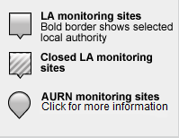
Guide to map markers:
Download uBreathe
The free app for iPhone, iPad & Android that gives you air pollution health advice - where and when you need it most
Find out more »